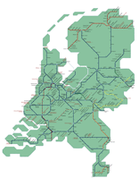
Kaart van het spoornetwerk in Nederland, treinen & verbindingen van NS, Arriva, Syntus, Connexxion en Veolia. |
De trein spoorlijnen kaart van de Nederlandse spoorwegen. Op deze spoorlijnenkaart kunt u direct zien via welke route en welke stations u (het dichtst) bij uw bestemming kunt komen. Het is een kaart met alle spoorlijnen en stations. Van NS, Arriva, Syntus, Connexxion en Veolia. Op de kaart staat informatie over de actieve trein-maatschappijen met alle treinen en boemeltjes, elk spoor en elke spoorlijn. De Nederlandse spoorkaart toont op overzichtelijke wijze de informatie van het spoorboekje.
The Netherlands is served by an extensive rail system as you can see in the map above. There is fast train service from Schiphol airport to central Amsterdam.
There are three classes of trains in Holland: the Intercity, which offers fast city-to-city connections, the Sneltrein, and lastly, the Stoptrein which makes more frequent stops at the smaller stations. Most stations are centrally located. The longest train trip within the Netherlands is approximately three hours.
火车
地图
网络
荷兰
荷兰的火车地图


